
weather maps
Page 1 of 1

Re: weather maps
![]() by dean Sat Aug 28, 2021 6:43 am
by dean Sat Aug 28, 2021 6:43 am
you must be logged in to click on links...
https://weatherspark.com/h/y/149720/2024/Historical-Weather-during-2024-at-Manuel-M%C3%A1rquez-de-Le%C3%B3n-International-Airport-Mexico#Sections-Sun
https://www.facebook.com/photo/?fbid=808961481258400&set=a.404424961712056
https://www.msn.com/en-us/weather/maps/airquality/in-La-Paz,Baja-California-Sur?loc=eyJsIjoiTGEgUGF6IiwiciI6IkJhamEgQ2FsaWZvcm5pYSBTdXIiLCJjIjoiTWV4aWNvIiwiaSI6Ik1YIiwiZyI6ImVuLXVzIiwieCI6Ii0xMTAuMzE4NDEzMyIsInkiOiIyNC4xMDQ5Njg0NCJ9&weadegreetype=C&ocid=winp1taskbar&cvid=8c8912d9bd17430ef6e305942c4b0402&zoom=8&fbclid=IwAR3zlDo0X9CI6-_b35lvVNm5IyO8N00lx3QxFyJOod_tzRHDb1j2J7Jqn-0
tides
https://wisuki.com/tide/3451/la-ventana?fbclid=IwAR1id5uPz8MQIsSyWRGSF3sZCBXSr8A2mpWiDpCx4DB_BxM1bUWfdxrNqqs
http://www.eebmike.com/
https://earth.nullschool.net/#current/wind/surface/level/orthographic=-108.75,23.58,2554
https://www.tropicaltidbits.com/sat/satlooper.php?region=09E&product=ir&fbclid=IwAR38RFw12wHUv2ebefz0Ky2TsRWU6KsEPYiXeALC2iY3zBmGIxhfC5NUUXQ
https://www.star.nesdis.noaa.gov/GOES/sector.php?sat=G16§or=mex
https://www.facebook.com/cmptiempo/
https://www.windy.com/-Satellite-satellite?satellite,23.327,-110.542,8

https://smn.conagua.gob.mx/es/animacion-imagenes-de-satelite?satelite=GOES%20Este&nombre=Noroeste%20de%20M%C3%A9xico&tipo=Tope%20de%20Nubes


https://www.star.nesdis.noaa.gov/GOES/floater.php?stormid=EP052021#navLink
https://smn.conagua.gob.mx/es/
click here for cabo radar
https://smn.conagua.gob.mx/tools/GUI/visor_radares/radares/cabos/cabos_ppi_gif.php?kche=090521110539
https://smn.conagua.gob.mx/tools/GUI/visor_radares_v3/index.html#/cabos/ppi_refl_450
https://smn.conagua.gob.mx/es/


https://www.cyclocane.com/
https://www.nhc.noaa.gov/gtwo.php
https://www.nhc.noaa.gov/cyclones/
a

aa
https://www.cyclocane.com/iselle-spaghetti-models/

b

c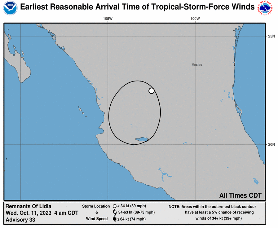
d
water temp
http://www.tempbreak.com/index.php?&cwregion=ml
e
http://www.tempbreak.com/index.php?&cwregion=cb&fbclid=IwAR34MPOlEmjF3bFAHIgtiENYiIG7EiTlt2ea6T3zIVzTxY6KRSzYn0gaL8Y
https://smn.conagua.gob.mx/es/
f

g
h
i
j

k
l

m
n
This below link Los Planes weather...
o
https://www.meteoblue.com/en/weather/forecast/week/san-juan-de-los-planes_mexico_4022410
a note for those of us that are close to the beach, when the temp is at the high for the day we are generally 6-10 degrees cooler than Los Planes, so I included El Cardonal which is similar to us on the water, their temperature is really close to ours during the day.. we might be a degree or two lower.
here is a better one for what our beach area actual temperture is Los Planes is to far inland
p
here is a very good link for all wind rain condition. https://www.windyty.com/24.149/-110.324?gust,2015-11-28-18,23.657,-107.589,8
q

r
https://cdn.star.nesdis.noaa.gov/GOES16/ABI/SECTOR/mex/15/20201911850_GOES16-ABI-mex-15-2000x2000.jpg

s
https://www.ssd.noaa.gov/goes/west/
t
https://cdn.star.nesdis.noaa.gov/GOES17/ABI/SECTOR/tpw/13/20201911850_GOES17-ABI-tpw-13-900x540.jpg
https://www.star.nesdis.noaa.gov/GOES/sector_band.php?sat=G17§or=tpw&band=13&length=12

u

v

w

x
[img(900px,540px)]https://cdn.star.nesdis.noaa.gov/GOES16/ABI/SECTOR/eep/13/GOES16-EEP-13-900x540.gif/img]
https://weatherspark.com/h/y/149720/2024/Historical-Weather-during-2024-at-Manuel-M%C3%A1rquez-de-Le%C3%B3n-International-Airport-Mexico#Sections-Sun
https://www.facebook.com/photo/?fbid=808961481258400&set=a.404424961712056
https://www.msn.com/en-us/weather/maps/airquality/in-La-Paz,Baja-California-Sur?loc=eyJsIjoiTGEgUGF6IiwiciI6IkJhamEgQ2FsaWZvcm5pYSBTdXIiLCJjIjoiTWV4aWNvIiwiaSI6Ik1YIiwiZyI6ImVuLXVzIiwieCI6Ii0xMTAuMzE4NDEzMyIsInkiOiIyNC4xMDQ5Njg0NCJ9&weadegreetype=C&ocid=winp1taskbar&cvid=8c8912d9bd17430ef6e305942c4b0402&zoom=8&fbclid=IwAR3zlDo0X9CI6-_b35lvVNm5IyO8N00lx3QxFyJOod_tzRHDb1j2J7Jqn-0
tides
https://wisuki.com/tide/3451/la-ventana?fbclid=IwAR1id5uPz8MQIsSyWRGSF3sZCBXSr8A2mpWiDpCx4DB_BxM1bUWfdxrNqqs
http://www.eebmike.com/
https://earth.nullschool.net/#current/wind/surface/level/orthographic=-108.75,23.58,2554
https://www.tropicaltidbits.com/sat/satlooper.php?region=09E&product=ir&fbclid=IwAR38RFw12wHUv2ebefz0Ky2TsRWU6KsEPYiXeALC2iY3zBmGIxhfC5NUUXQ
https://www.star.nesdis.noaa.gov/GOES/sector.php?sat=G16§or=mex
https://www.facebook.com/cmptiempo/
https://www.windy.com/-Satellite-satellite?satellite,23.327,-110.542,8
https://smn.conagua.gob.mx/es/animacion-imagenes-de-satelite?satelite=GOES%20Este&nombre=Noroeste%20de%20M%C3%A9xico&tipo=Tope%20de%20Nubes
https://www.star.nesdis.noaa.gov/GOES/floater.php?stormid=EP052021#navLink
https://smn.conagua.gob.mx/es/
click here for cabo radar
https://smn.conagua.gob.mx/tools/GUI/visor_radares/radares/cabos/cabos_ppi_gif.php?kche=090521110539
https://smn.conagua.gob.mx/tools/GUI/visor_radares_v3/index.html#/cabos/ppi_refl_450
https://smn.conagua.gob.mx/es/
https://www.cyclocane.com/
https://www.nhc.noaa.gov/gtwo.php
https://www.nhc.noaa.gov/cyclones/
a
aa
https://www.cyclocane.com/iselle-spaghetti-models/
b
c
d
water temp
http://www.tempbreak.com/index.php?&cwregion=ml
e
http://www.tempbreak.com/index.php?&cwregion=cb&fbclid=IwAR34MPOlEmjF3bFAHIgtiENYiIG7EiTlt2ea6T3zIVzTxY6KRSzYn0gaL8Y
https://smn.conagua.gob.mx/es/
f
g
h
i

j
k

l
m
n
This below link Los Planes weather...
o
https://www.meteoblue.com/en/weather/forecast/week/san-juan-de-los-planes_mexico_4022410
a note for those of us that are close to the beach, when the temp is at the high for the day we are generally 6-10 degrees cooler than Los Planes, so I included El Cardonal which is similar to us on the water, their temperature is really close to ours during the day.. we might be a degree or two lower.
here is a better one for what our beach area actual temperture is Los Planes is to far inland
p
here is a very good link for all wind rain condition. https://www.windyty.com/24.149/-110.324?gust,2015-11-28-18,23.657,-107.589,8
q
r
https://cdn.star.nesdis.noaa.gov/GOES16/ABI/SECTOR/mex/15/20201911850_GOES16-ABI-mex-15-2000x2000.jpg
s
https://www.ssd.noaa.gov/goes/west/
t
https://cdn.star.nesdis.noaa.gov/GOES17/ABI/SECTOR/tpw/13/20201911850_GOES17-ABI-tpw-13-900x540.jpg
https://www.star.nesdis.noaa.gov/GOES/sector_band.php?sat=G17§or=tpw&band=13&length=12
u
v
w
x
[img(900px,540px)]https://cdn.star.nesdis.noaa.gov/GOES16/ABI/SECTOR/eep/13/GOES16-EEP-13-900x540.gif/img]
Last edited by dean on Fri Aug 25, 2023 9:52 am; edited 4 times in total
dean- Posts : 5539
Join date : 2008-01-01
floydo likes this post
Re: weather maps
![]() by dean Fri Sep 20, 2019 5:41 pm
by dean Fri Sep 20, 2019 5:41 pm

infrared Sat link


http://www.goes.noaa.gov/HURRLOOPS/hpir.html
windy tv
http://tropic.ssec.wisc.edu/tropic.php#
good weather history
https://www.worldweatheronline.com/la-ventana-weather/baja-california-sur/mx.aspx?wwo_r=srch
a vis sat

b infrared

c water vapor

https://www.star.nesdis.noaa.gov/GOES/index.php
https://weather.msfc.nasa.gov/goes/abi/goesWestfullDiskband13.html
https://www.nhc.noaa.gov/cyclones/
lapaz airport https://w1.weather.gov/data/obhistory/MMLP.html
lapaz tide chart https://www.tideschart.com/Mexico/Baja-California-Sur/La-Paz/
lapaz 10 day forcast https://www.wunderground.com/forecast/ILAPAZ34?cm_ven=localwx_10day
https://www.facebook.com/MetmexBCS/
https://sites.google.com/site/bcsclima/?fbclid=IwAR18EcGCqBFzaOTLFmWEuboFtyHwwxOyu86xfRgIX0eRc8qVDJ3CUoEOKD0
https://weather.com/weather/radar/interactive/l/370b1147fa4ec05351749f31004bee089f7f3f0d568ec17e9ed6c9ac4f94295f?base=roadsLight&layer=satir&series=observation&zoom=6.10&opacity=70¢er=23.25%2C-110.28&overlays=tropicalstorms&fbclid=IwAR0iPoSZud5acM_qI6L4ABA9bXlq4edX2cfvNbrcrz8L98f1Ji15Y6lUYYA
cabo radar
here is a good one to look at, click this link..
https://www.nhc.noaa.gov/refresh/graphics_ep2+shtml/235538.shtml?gm_track#contents
https://smn.conagua.gob.mx/es/pronosticos/avisos/aviso-de-ciclon-tropical-en-el-oceano-pacifico
z
(800px,600px)]https://smn.conagua.gob.mx
(800px,800px)]https://smn.conagua.gob.mx
a

aa

aaa

aaaa

c

d
https://smn.conagua.gob.mx/es/animacion-imagenes-de-satelite?satelite=GOES%20Este&nombre=Pac%C3%ADfico%20-%20Sur&tipo=Topes%20de%20Nubes
https://smn.conagua.gob.mx/es/animacion-imagenes-de-satelite?satelite=GOES%20Este&nombre=Pac%C3%ADfico%20-%20Sur&tipo=Topes%20de%20Nubes

e
https://weather.msfc.nasa.gov/goes/abi/goesEastconusband13.html

f

g
https://www.nhc.noaa.gov/refresh/graphics_ep4+shtml/203350.shtml?cone#contents

h

i
 " />
" />Last edited by dean on Sat Jun 11, 2022 7:45 am; edited 7 times in total
dean- Posts : 5539
Join date : 2008-01-01
Re: weather maps
![]() by dean Mon Aug 06, 2018 9:41 pm
by dean Mon Aug 06, 2018 9:41 pm
https://www.star.nesdis.noaa.gov/GOES/floater.php?stormid=EP052021#navLink
https://smn.conagua.gob.mx/es/
click here for cabo radar
https://smn.conagua.gob.mx/tools/GUI/visor_radares/radares/cabos/cabos_ppi_gif.php?kche=090521110539
https://www.cyclocane.com/
https://www.nhc.noaa.gov/refresh/graphics_ep1+shtml/083340.shtml?cone#contents
https://www.cyclocane.com/iselle-spaghetti-models/
a
static pictures, these may not update so you can see progression.
static ie not changing, moved to https://www.laventanarocks.com/t1243-hurricanes-2023#6195
f
g
water temp
http://www.tempbreak.com/index.php?&cwregion=ml
h
http://www.tempbreak.com/index.php?&cwregion=cb&fbclid=IwAR34MPOlEmjF3bFAHIgtiENYiIG7EiTlt2ea6T3zIVzTxY6KRSzYn0gaL8Y
https://smn.conagua.gob.mx/es/
i
Last edited by dean on Sat Aug 19, 2023 5:02 pm; edited 12 times in total
dean- Posts : 5539
Join date : 2008-01-01
Re: weather maps
![]() by dean Mon Feb 19, 2018 10:39 pm
by dean Mon Feb 19, 2018 10:39 pm
.
Last edited by dean on Thu Jul 09, 2020 1:32 pm; edited 2 times in total
dean- Posts : 5539
Join date : 2008-01-01
Re: weather maps
![]() by dean Sun Jul 09, 2017 10:45 pm
by dean Sun Jul 09, 2017 10:45 pm
https://www.weather.gov/forecastmaps
http://www.nhc.noaa.gov/graphics_ep2.shtml?5-daynl#contents
a1
cabo airport
http://w1.weather.gov/data/obhistory/MMSD.html
LaPaz airport
http://w1.weather.gov/data/obhistory/MMLP.html
a

b

c
https://www.nhc.noaa.gov/
d
08:56:10

us weather http://water.weather.gov/precip/index.php?yday=1379116800&yday_analysis=0&layer%5B%5D=0&layer%5B%5D=1&layer%5B%5D=4&timetype=RECENT&loctype=STATE&units=engl&timeframe=last14days&product=observed&loc=conus
I added some webcam links for cabo at the bottom of the page. that way you can see it as it is approaching.
http://www.cyclocane.com/javier-storm-tracker/
https://twitter.com/metmex
https://www.facebook.com/groups/727074667339978/
http://www.nhc.noaa.gov/cyclones/?epac
g water vapor
h precipitateable water
http://www.nhc.noaa.gov/graphics_ep2.shtml?5-daynl#contents
a1
cabo airport
http://w1.weather.gov/data/obhistory/MMSD.html
LaPaz airport
http://w1.weather.gov/data/obhistory/MMLP.html
a
b
c
https://www.nhc.noaa.gov/
d
08:56:10
us weather http://water.weather.gov/precip/index.php?yday=1379116800&yday_analysis=0&layer%5B%5D=0&layer%5B%5D=1&layer%5B%5D=4&timetype=RECENT&loctype=STATE&units=engl&timeframe=last14days&product=observed&loc=conus
I added some webcam links for cabo at the bottom of the page. that way you can see it as it is approaching.
http://www.cyclocane.com/javier-storm-tracker/
https://twitter.com/metmex
https://www.facebook.com/groups/727074667339978/
http://www.nhc.noaa.gov/cyclones/?epac
g water vapor
h precipitateable water
Last edited by dean on Thu Jul 09, 2020 1:40 pm; edited 12 times in total
dean- Posts : 5539
Join date : 2008-01-01
storm
![]() by dean Mon Sep 28, 2015 8:50 pm
by dean Mon Sep 28, 2015 8:50 pm
http://www.ssd.noaa.gov/PS/TROP/Basin_EastPac.html
lapaz airport weather last 24 hours
http://tropic.ssec.wisc.edu/tropic.php#
http://tropic.ssec.wisc.edu/
http://smn.cna.gob.mx/es/
http://smn.cna.gob.mx/es/pronosticos/avisos/aviso-de-ciclon-tropical-en-el-oceano-pacifico
http://smn.cna.gob.mx/es/observando-el-tiempo/imagenes-de-satelite
these 1-11 could be old as some do not auto-refresh, check the date and time printed on it and if you want the current click the link above
1 http://smn.cna.gob.mx/es/pronosticos/avisos/aviso-de-ciclon-tropical-en-el-oceano-pacifico
this one does not refresh well, you may have to go to the above website.
http://smn.cna.gob.mx/tools/RESOURCES/GOES/GOES%20Este/Pac%C3%ADfico%20-%20Sur/Topes%20de%20Nubes/MEDIA/201806082045.jpg
2 http://smn.cna.gob.mx/es/pronosticos/avisos/aviso-de-ciclon-tropical-en-el-oceano-pacifico
this one does not auto refresh either
http://smn.cna.gob.mx/es/pronosticos/avisos/aviso-de-ciclon-tropical-en-el-oceano-pacifico
http://smn.cna.gob.mx/tools/IMG/visforms/p-3132-temp1.jpg

3
http://smn.cna.gob.mx/es/pronosticos/avisos/aviso-de-ciclon-tropical-en-el-oceano-pacifico
4
http://smn.cna.gob.mx/es/observando-el-tiempo/imagenes-de-satelite
5
http://smn.cna.gob.mx/es/observando-el-tiempo/imagenes-de-satelite
http://smn.cna.gob.mx/es/pronosticos/pronosticossubmenu/pronostico-meteorologico-general
6, http://smn.cna.gob.mx/es/pronosticos/pronosticossubmenu/reporte-de-lluvia-acumulada-de-tres-dias
rain total
7
http://smn.cna.gob.mx/es/pronosticos/pronosticossubmenu/pronostico-extendido-a-96-horas
8
http://smn.cna.gob.mx/es/pronosticos/pronosticossubmenu/pronostico-meteorologico-general

http://smn.cna.gob.mx/tools/RESOURCES/GOES/GOES%20Oeste/Pac%C3%ADfico%20Extendido/Dvorak/MEDIA/201708301909.jpg
http://smn.cna.gob.mx/es/pronosticos/pronosticossubmenu/pronostico-meteorologico-general
9
http://smn.cna.gob.mx/es/imagen-sobresaliente

http://smn.cna.gob.mx/tools/RESOURCES/GOES/GOES%20Este/Pac%C3%ADfico%20-%20Sur/Infrarroja/MEDIA/201708301615.jpg
10 http://smn.cna.gob.mx/es/pronosticos/avisos/aviso-de-ciclon-tropical-en-el-oceano-pacifico
http://smn.cna.gob.mx/tools/RESOURCES/GOES/GOES%20Este/Pac%C3%ADfico%20-%20Sur/Topes%20de%20nubes/MEDIA/201708301900.jpg
11 Satélite GOES Oeste Pacífico Extendido Dvorak
https://en.wikipedia.org/wiki/Dvorak_technique
http://smn.cna.gob.mx/es/observando-el-tiempo/imagenes-de-satelite
http://www.ustream.tv/channel/iss-hdev-payload
lapaz airport weather last 24 hours
http://tropic.ssec.wisc.edu/tropic.php#
http://tropic.ssec.wisc.edu/
http://smn.cna.gob.mx/es/
http://smn.cna.gob.mx/es/pronosticos/avisos/aviso-de-ciclon-tropical-en-el-oceano-pacifico
http://smn.cna.gob.mx/es/observando-el-tiempo/imagenes-de-satelite
these 1-11 could be old as some do not auto-refresh, check the date and time printed on it and if you want the current click the link above
1 http://smn.cna.gob.mx/es/pronosticos/avisos/aviso-de-ciclon-tropical-en-el-oceano-pacifico
this one does not refresh well, you may have to go to the above website.
http://smn.cna.gob.mx/tools/RESOURCES/GOES/GOES%20Este/Pac%C3%ADfico%20-%20Sur/Topes%20de%20Nubes/MEDIA/201806082045.jpg
2 http://smn.cna.gob.mx/es/pronosticos/avisos/aviso-de-ciclon-tropical-en-el-oceano-pacifico
this one does not auto refresh either
http://smn.cna.gob.mx/es/pronosticos/avisos/aviso-de-ciclon-tropical-en-el-oceano-pacifico
http://smn.cna.gob.mx/tools/IMG/visforms/p-3132-temp1.jpg
3
http://smn.cna.gob.mx/es/pronosticos/avisos/aviso-de-ciclon-tropical-en-el-oceano-pacifico
4
http://smn.cna.gob.mx/es/observando-el-tiempo/imagenes-de-satelite
5
http://smn.cna.gob.mx/es/observando-el-tiempo/imagenes-de-satelite
http://smn.cna.gob.mx/es/pronosticos/pronosticossubmenu/pronostico-meteorologico-general
6, http://smn.cna.gob.mx/es/pronosticos/pronosticossubmenu/reporte-de-lluvia-acumulada-de-tres-dias
rain total
7
http://smn.cna.gob.mx/es/pronosticos/pronosticossubmenu/pronostico-extendido-a-96-horas
8
http://smn.cna.gob.mx/es/pronosticos/pronosticossubmenu/pronostico-meteorologico-general
http://smn.cna.gob.mx/tools/RESOURCES/GOES/GOES%20Oeste/Pac%C3%ADfico%20Extendido/Dvorak/MEDIA/201708301909.jpg
http://smn.cna.gob.mx/es/pronosticos/pronosticossubmenu/pronostico-meteorologico-general
9
http://smn.cna.gob.mx/es/imagen-sobresaliente
http://smn.cna.gob.mx/tools/RESOURCES/GOES/GOES%20Este/Pac%C3%ADfico%20-%20Sur/Infrarroja/MEDIA/201708301615.jpg
10 http://smn.cna.gob.mx/es/pronosticos/avisos/aviso-de-ciclon-tropical-en-el-oceano-pacifico
http://smn.cna.gob.mx/tools/RESOURCES/GOES/GOES%20Este/Pac%C3%ADfico%20-%20Sur/Topes%20de%20nubes/MEDIA/201708301900.jpg
11 Satélite GOES Oeste Pacífico Extendido Dvorak
https://en.wikipedia.org/wiki/Dvorak_technique
http://smn.cna.gob.mx/es/observando-el-tiempo/imagenes-de-satelite
http://www.ustream.tv/channel/iss-hdev-payload
Last edited by dean on Sat Jul 20, 2019 8:25 am; edited 42 times in total
dean- Posts : 5539
Join date : 2008-01-01
Re: weather maps
![]() by dean Mon Jun 01, 2015 9:51 am
by dean Mon Jun 01, 2015 9:51 am
http://www.nhc.noaa.gov/cyclones/?epac
http://www.nhc.noaa.gov/xgtwo/two_pac_2d0.png
---

real cool map.... can not stream it live here you have to click the link below here.
http://earth.nullschool.net/
another cool map that i can not stream live
http://weather.msfc.nasa.gov/GOES/goeswestfullir.html
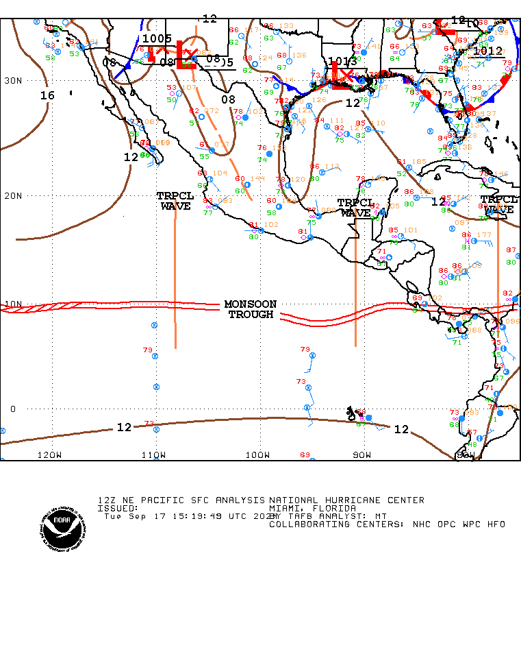
TROPICAL WEATHER DISCUSSION in text
http://www.nhc.noaa.gov/text/MIATWDEP.shtml
http://www.nhc.noaa.gov/xgtwo/two_pac_2d0.png
---
real cool map.... can not stream it live here you have to click the link below here.
http://earth.nullschool.net/
another cool map that i can not stream live
http://weather.msfc.nasa.gov/GOES/goeswestfullir.html
TROPICAL WEATHER DISCUSSION in text
http://www.nhc.noaa.gov/text/MIATWDEP.shtml
Last edited by dean on Thu Jul 09, 2020 1:31 pm; edited 16 times in total
dean- Posts : 5539
Join date : 2008-01-01
Re: weather maps
![]() by dean Mon Feb 16, 2015 3:41 am
by dean Mon Feb 16, 2015 3:41 am
http://www.nhc.noaa.gov/?epac
l
https://www.windyty.com/?2015-07-13-09,16.383,-67.676,3
k
https://www.servirglobal.net/Mesoamerica/MapsData/InteractiveMapper.aspx
j
https://www.servirglobal.net/Mesoamerica/MapsData/InteractiveMapper.aspx?savedMapID=6bb1a2d3-a200-439f-8742-72262bf77081
i
https://weather.cod.edu/satrad/exper/
h
http://www.goes.noaa.gov/
g
d
http://rammb.cira.colostate.edu/ramsdis/online/rmtc.asp
https://www.star.nesdis.noaa.gov/GOES/index.php
http://rammb.cira.colostate.edu/ramsdis/online/loop.asp?data_folder=rmtc/rmtcsasec5ir304&width=640&height=480

c

b
a

l
https://www.windyty.com/?2015-07-13-09,16.383,-67.676,3
k
https://www.servirglobal.net/Mesoamerica/MapsData/InteractiveMapper.aspx
j
https://www.servirglobal.net/Mesoamerica/MapsData/InteractiveMapper.aspx?savedMapID=6bb1a2d3-a200-439f-8742-72262bf77081
i
https://weather.cod.edu/satrad/exper/
h
http://www.goes.noaa.gov/
g
d
http://rammb.cira.colostate.edu/ramsdis/online/rmtc.asp
https://www.star.nesdis.noaa.gov/GOES/index.php
http://rammb.cira.colostate.edu/ramsdis/online/loop.asp?data_folder=rmtc/rmtcsasec5ir304&width=640&height=480
c
b
a
Last edited by dean on Thu Jul 09, 2020 1:19 pm; edited 25 times in total
dean- Posts : 5539
Join date : 2008-01-01
another one
![]() by dean Sat Sep 13, 2014 9:02 pm
by dean Sat Sep 13, 2014 9:02 pm
https://www.wunderground.com/
http://www.nhc.noaa.gov/text/MIATWDEP.shtml
TROPICAL WEATHER DISCUSSION
NWS NATIONAL HURRICANE CENTER MIAMI FL
1605 UTC WED OCT 01 2014
good resource
http://www.thefishingweatherman.com/index.php/forecasts
on this link click on the storm in the picture to get the tracking
http://tropic.ssec.wisc.edu/#
http://tropic.ssec.wisc.edu/real-time/tc_diurnal_cycle/tc_diurnal_cycle.php
http://tropic.ssec.wisc.edu/real-time/tc_diurnal_cycle/tc_diurnal_cycle.storm.php?&period=3day&storm=12E
http://tropic.ssec.wisc.edu/real-time/tc_diurnal_cycle/TC_DIURNAL-COMBO-12E.jpg
Last edited by dean on Thu Aug 20, 2020 7:52 am; edited 11 times in total
dean- Posts : 5539
Join date : 2008-01-01
Re: weather maps
![]() by dean Wed Sep 10, 2014 11:58 am
by dean Wed Sep 10, 2014 11:58 am
http://www.nhc.noaa.gov/cyclones/?epac

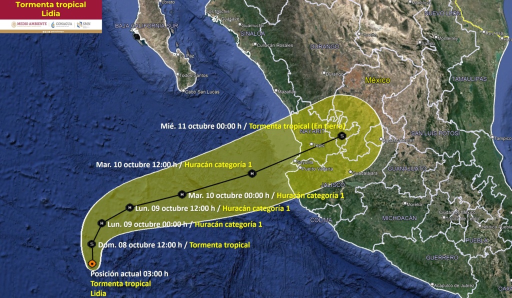
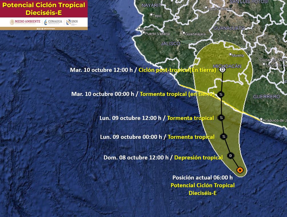
This graphic shows an approximate representation of coastal areas under a hurricane warning (red), hurricane watch (pink), tropical storm warning (blue) and tropical storm watch (yellow). The orange circle indicates the current position of the center of the tropical cyclone. The black line, when selected, and dots show the National Hurricane Center (NHC) forecast track of the center at the times indicated. The dot indicating the forecast center location will be black if the cyclone is forecast to be tropical and will be white with a black outline if the cyclone is forecast to be extratropical. If only an L is displayed, then the system is forecast to be a remnant low. The letter inside the dot indicates the NHC's forecast intensity for that time:
D: Tropical Depression – wind speed less than 39 MPH
S: Tropical Storm – wind speed between 39 MPH and 73 MPH
H: Hurricane – wind speed between 74 MPH and 110 MPH
M: Major Hurricane – wind speed greater than 110 MPH
NHC tropical cyclone forecast tracks can be in error. This forecast uncertainty is conveyed by the track forecast "cone", the solid white and stippled white areas in the graphic. The solid white area depicts the track forecast uncertainty for days 1-3 of the forecast, while the stippled area depicts the uncertainty on days 4-5. Historical data indicate that the entire 5-day path of the center of the tropical cyclone will remain within the cone about 60-70% of the time. To form the cone, a set of imaginary circles are placed along the forecast track at the 12, 24, 36, 48, 72, 96, and 120 h positions, where the size of each circle is set so that it encloses 67% of the previous five years official forecast errors. The cone is then formed by smoothly connecting the area swept out by the set of circles.
It is also important to realize that a tropical cyclone is not a point. Their effects can span many hundreds of miles from the center. The area experiencing hurricane force (one-minute average wind speeds of at least 74 mph) and tropical storm force (one-minute average wind speeds of 39-73 mph) winds can extend well beyond the white areas shown enclosing the most likely track area of the center. The distribution of hurricane and tropical storm force winds in this tropical cyclone can be seen in the Wind History graphic linked above.
Considering the combined forecast uncertainties in track, intensity, and size, the chances that any particular location will experience winds of 34 kt (tropical storm force), 50 kt, or 64 kt (hurricane force) from this tropical cyclone are presented in tabular form for selected locations and forecast positions. This information is also presented in graphical form for the 34 kt, 50 kt, and
64 kt thresholds.
tide chart
http://tbone.biol.sc.edu/tide/tideshow.cgi?site=La+Paz%2C+Baja+California+Sur%2C+Mexico
another neat one was for hurricane marty.
https://www.windyty.com/?2015-06-07-18,19.560,-108.896,5
this is general.
Last edited by dean on Sun Sep 04, 2016 3:33 pm; edited 25 times in total
dean- Posts : 5539
Join date : 2008-01-01
weather maps
![]() by dean Wed Sep 04, 2013 8:02 am
by dean Wed Sep 04, 2013 8:02 am
for written warnings click this link
http://www.nhc.noaa.gov/text/MIATWDEP.shtml
http://www.nhc.noaa.gov/cyclones/?epac
laventana water temperture
https://seatemperature.info/la-ventana-water-temperature.html
start
http://smn.cna.gob.mx/index.php?option=com_content&view=article&id=10:imagenes-de-satelite-goes-este-&catid=6:slider&Itemid=85
http://smn.cna.gob.mx/satelite/goesE/mex/loop.gif
stop

http://preview.weather.gov/graphical/?zoom=3&lat=10.91198&lon=-68.37891&layers=00BFTFTTTTT®ion=7&element=9&mxmz=true&barbs=true
for written warnings
http://www.nhc.noaa.gov/text/MIATWDEP.shtml
http://www.nhc.noaa.gov/satellite.php
this is the best chart for water temp, I can not post because it is protected because of copyright so not able to show.
http://www.terrafin.com/sstview/showFreeChart.php?ct=free&zn=wcrv&rg=sobaja&ix=1
surface temp

http://www.swellmatrix.com/socal/sstbajasur.html

water temp
http://www.tempbreak.com/index.php?&cwregion=ml
http://www.tempbreak.com/index.php?&cwregion=cb&fbclid=IwAR34MPOlEmjF3bFAHIgtiENYiIG7EiTlt2ea6T3zIVzTxY6KRSzYn0gaL8Y


http://smn.cna.gob.mx/es/climatologia/diagnostico-climatico/enos
http://smn.cna.gob.mx/tools/IMG/visforms/sst_prom_5b1ef924a8a1f.jpg)
here are waves

http://magicseaweed.com/North-East-Pacific-Surf-Chart/24/?chartType=TMP#?chartType=TMP&_suid=137830751615607519982515368611
http://www.wunderground.com/wundermap/?lat=23.45000&lon=-110.21667&zoom=10&type=hybrid&units=metric&pin=Todos+Santos%2C+Mexico&plat=23.450001&plon=-110.216667&tl.play=0&tl.spd=2&viewportstart=now-3756&viewportend=now-156&groupSevere=1&groupHurricane=1&groupFire=1&groupCamsPhotos=1&groupRealEstate=1&eyedropper=0&extremes=0&fault=0&favs=0&femaflood=0&fire=0&firewfas=0&fissures=0&fronts=0&hurrevac=0&hur=0&labels=0&lightning=0&livesurge=0&mm=0&ndfd=0&rad=0&dir=1&dir.mode=driving&sst=0&sat=0&seismicrisk=0&svr=0&ski=0&snowfall=0&stormreports=0&tor=0&tfk=0&tsunami=0&riv=0&wxsn=0&cams=0&pix=0
for written warnings
http://www.nhc.noaa.gov/text/MIATWDEP.shtml
http://www.nhc.noaa.gov/satellite.php
wind
other good sites
http://www.stormsurf.com/locals/cabo.shtml
http://www.cyclocane.com/
real cool map.... can not stream it live here you have to click the link below here.
http://earth.nullschool.net/
below is old, click above link for current
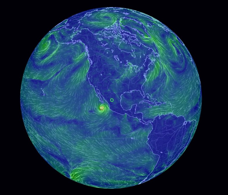
Like the US-specific wind map created by designers Fernanda Viégas and Martin Wattenberg earlier this year, Earth Wind Map is interactive. Click and drag the globe and you'll spin it in place, then wait a few seconds before the data appears in the form of snaking lines. Gentle breezes are thin strands of green, strong winds are long streaks of bright yellow, while the strongest currents are an angry red. Take a trip around Earth Wind Map's globe now and you'll be able to compare the light summer winds currently wafting across northern Brazil with the swirling gusts off the north-east coast of Japan, a hypnotic and colorful reminder of our planet's wildly changing weather.

cabo webcams,
http://www.cabovillas.com/webcams.asp
http://www.loscabosguide.com/cabosanlucas/webcams.htm
http://allaboutcabo.com/gallery/web-cam" />
http://www.nhc.noaa.gov/text/MIATWDEP.shtml
http://www.nhc.noaa.gov/cyclones/?epac
laventana water temperture
https://seatemperature.info/la-ventana-water-temperature.html
start
http://smn.cna.gob.mx/index.php?option=com_content&view=article&id=10:imagenes-de-satelite-goes-este-&catid=6:slider&Itemid=85
http://smn.cna.gob.mx/satelite/goesE/mex/loop.gif
stop
http://preview.weather.gov/graphical/?zoom=3&lat=10.91198&lon=-68.37891&layers=00BFTFTTTTT®ion=7&element=9&mxmz=true&barbs=true
for written warnings
http://www.nhc.noaa.gov/text/MIATWDEP.shtml
http://www.nhc.noaa.gov/satellite.php
this is the best chart for water temp, I can not post because it is protected because of copyright so not able to show.
http://www.terrafin.com/sstview/showFreeChart.php?ct=free&zn=wcrv&rg=sobaja&ix=1
surface temp
http://www.swellmatrix.com/socal/sstbajasur.html
water temp
http://www.tempbreak.com/index.php?&cwregion=ml
http://www.tempbreak.com/index.php?&cwregion=cb&fbclid=IwAR34MPOlEmjF3bFAHIgtiENYiIG7EiTlt2ea6T3zIVzTxY6KRSzYn0gaL8Y
http://smn.cna.gob.mx/es/climatologia/diagnostico-climatico/enos
here are waves
http://magicseaweed.com/North-East-Pacific-Surf-Chart/24/?chartType=TMP#?chartType=TMP&_suid=137830751615607519982515368611
http://www.wunderground.com/wundermap/?lat=23.45000&lon=-110.21667&zoom=10&type=hybrid&units=metric&pin=Todos+Santos%2C+Mexico&plat=23.450001&plon=-110.216667&tl.play=0&tl.spd=2&viewportstart=now-3756&viewportend=now-156&groupSevere=1&groupHurricane=1&groupFire=1&groupCamsPhotos=1&groupRealEstate=1&eyedropper=0&extremes=0&fault=0&favs=0&femaflood=0&fire=0&firewfas=0&fissures=0&fronts=0&hurrevac=0&hur=0&labels=0&lightning=0&livesurge=0&mm=0&ndfd=0&rad=0&dir=1&dir.mode=driving&sst=0&sat=0&seismicrisk=0&svr=0&ski=0&snowfall=0&stormreports=0&tor=0&tfk=0&tsunami=0&riv=0&wxsn=0&cams=0&pix=0
for written warnings
http://www.nhc.noaa.gov/text/MIATWDEP.shtml
http://www.nhc.noaa.gov/satellite.php
wind
other good sites
http://www.stormsurf.com/locals/cabo.shtml
http://www.cyclocane.com/
real cool map.... can not stream it live here you have to click the link below here.
http://earth.nullschool.net/
below is old, click above link for current

Like the US-specific wind map created by designers Fernanda Viégas and Martin Wattenberg earlier this year, Earth Wind Map is interactive. Click and drag the globe and you'll spin it in place, then wait a few seconds before the data appears in the form of snaking lines. Gentle breezes are thin strands of green, strong winds are long streaks of bright yellow, while the strongest currents are an angry red. Take a trip around Earth Wind Map's globe now and you'll be able to compare the light summer winds currently wafting across northern Brazil with the swirling gusts off the north-east coast of Japan, a hypnotic and colorful reminder of our planet's wildly changing weather.
cabo webcams,
http://www.cabovillas.com/webcams.asp
http://www.loscabosguide.com/cabosanlucas/webcams.htm
http://allaboutcabo.com/gallery/web-cam" />
Last edited by dean on Sat Aug 29, 2020 10:01 am; edited 28 times in total
dean- Posts : 5539
Join date : 2008-01-01
» active weather maps
» general discussion and weather maps
» accu weather and lapaz weather
» us map with weather
» for today,,,
» general discussion and weather maps
» accu weather and lapaz weather
» us map with weather
» for today,,,
Page 1 of 1
Permissions in this forum:
You cannot reply to topics in this forum