
hurricanes 2019
Page 1 of 1


dean- Posts : 5539
Join date : 2008-01-01


Re: hurricanes 2019
![]() by dean Sat Nov 16, 2019 8:36 am
by dean Sat Nov 16, 2019 8:36 am
yesterday and todays
fridays projection

next two saturdays projections 7am
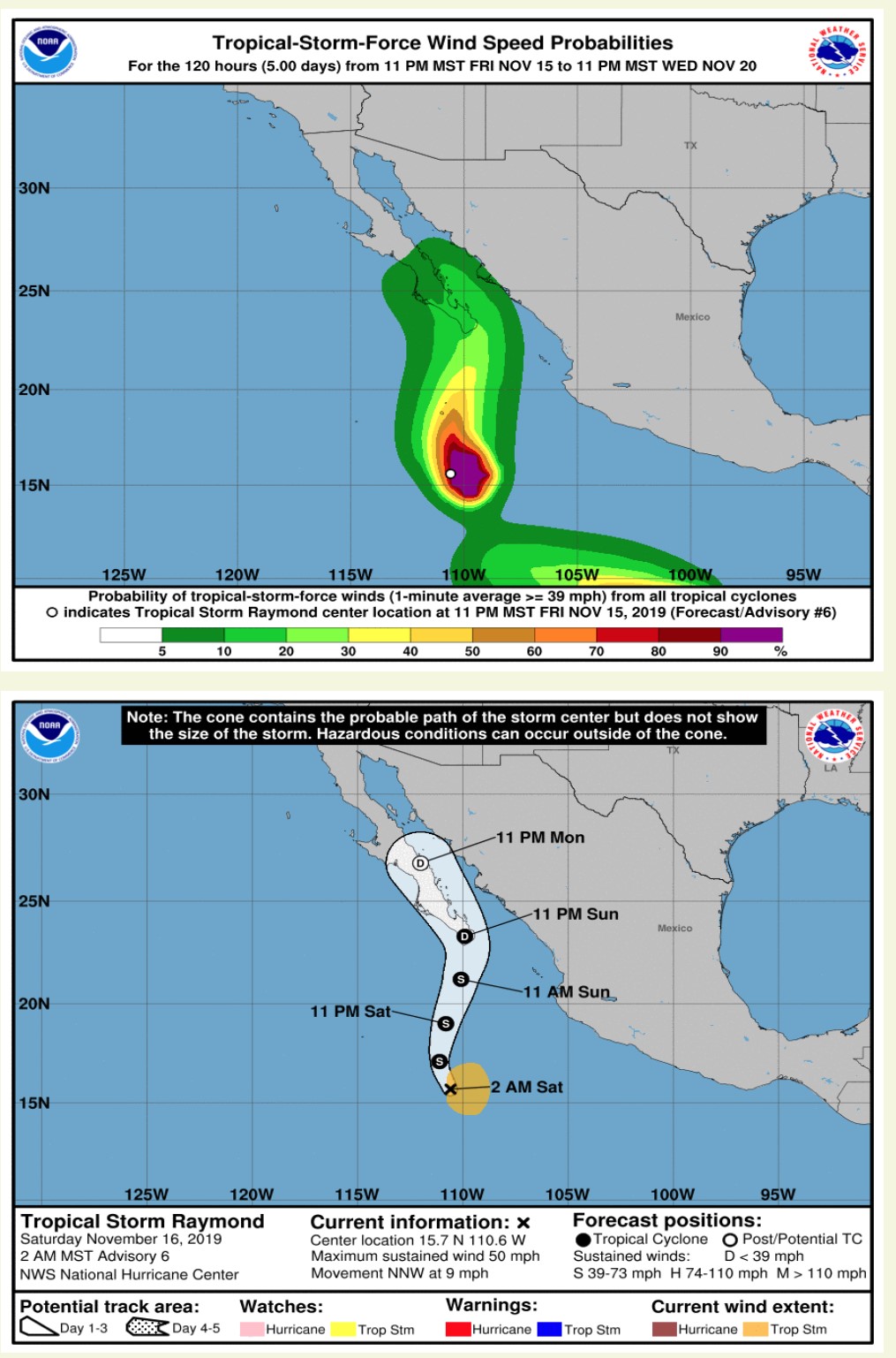

fridays projection

next two saturdays projections 7am


dean- Posts : 5539
Join date : 2008-01-01
Re: hurricanes 2019
![]() by dean Thu Nov 07, 2019 9:03 pm
by dean Thu Nov 07, 2019 9:03 pm
here is from facebook,
MasViento
Yesterday at 6:54 AM ·

MasViento
Yesterday at 6:54 AM ·
facebook MasViento wrote:
Buenos dias! No ASCAT pass last evening, but all numerical models show a background north flow should continue today. Infrared satellite loops show a large area of cloud cover streaming into BCS from the southwest, but there are indications of a least some thinning of this cloud shield. Although I don't think we'll luck out like we did yesterday and get a sunny afternoon, the clouds could thin just enough to allow some filtered sun to activate the thermal. Surface high pressure begins to build into the western U.S. tonight, with a substantial tightening of the surface pressure gradient Thursday into Friday over the Sea of Cortez. The surface high will begin to weaken slowly on Saturday, but solid north flow is expected to last into Tuesday. Again, high clouds will be a potential factor in the strength of the thermal Sunday through Tuesday.
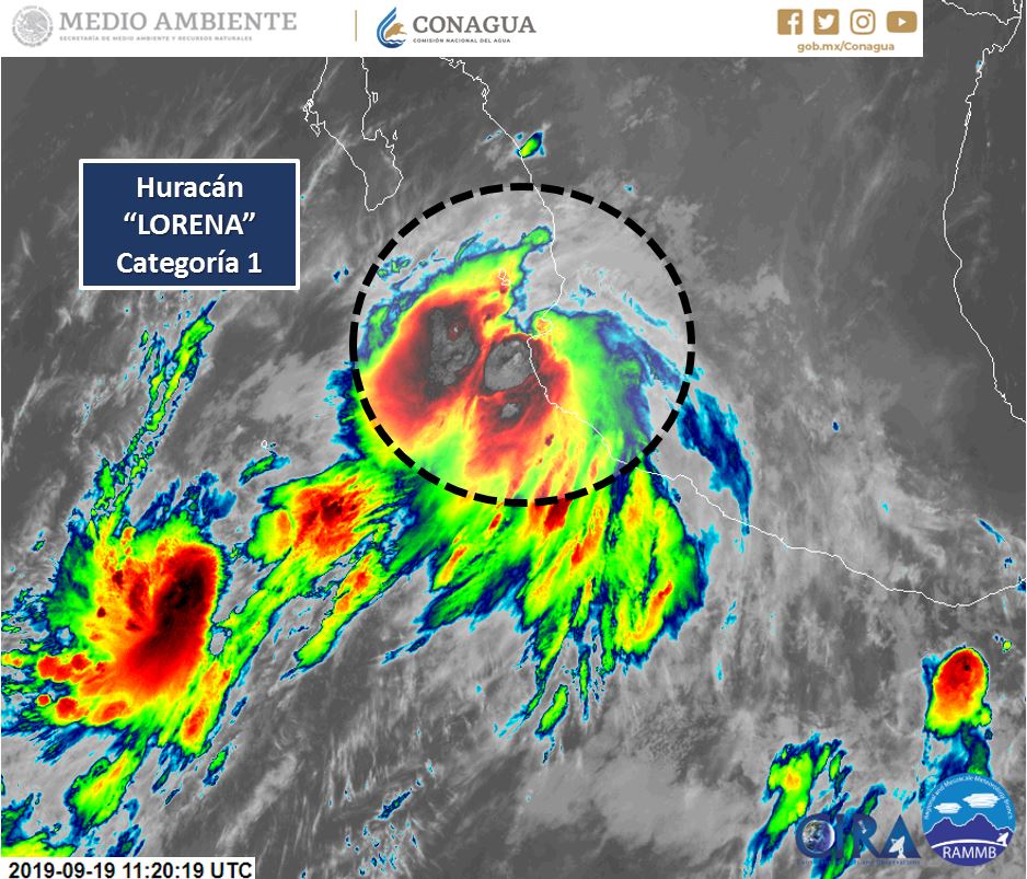
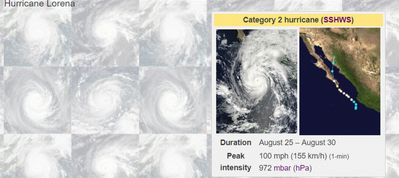
Nerd Note: Some of you have asked me about Hurricane Lorena. I've summarized my experiences and some forecast information below.
Today...Partly sunny. North wind 14-16 mph.
Thursday...Mostly sunny. North wind 18-22 mph.
Friday...Mostly sunny. North wind 20-24 mph.
Saturday...Mostly sunny. North wind 18-22 mph.
Sunday...Partly sunny. North wind 16-18 mph.
Monday...Partly sunny. North wind 16-18 mph.
Tuesday...Partly sunny. North wind 16-18 mph.
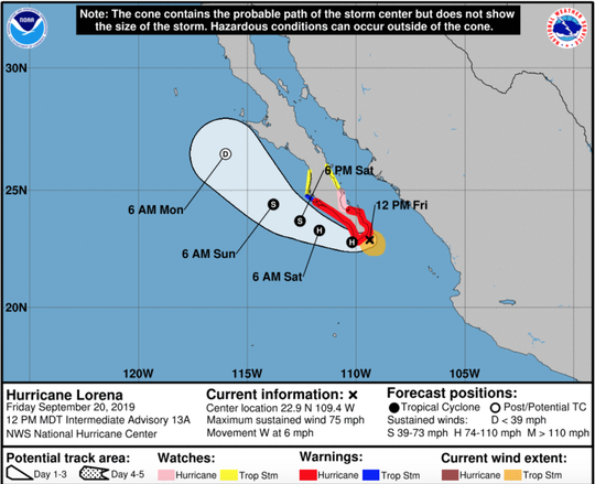
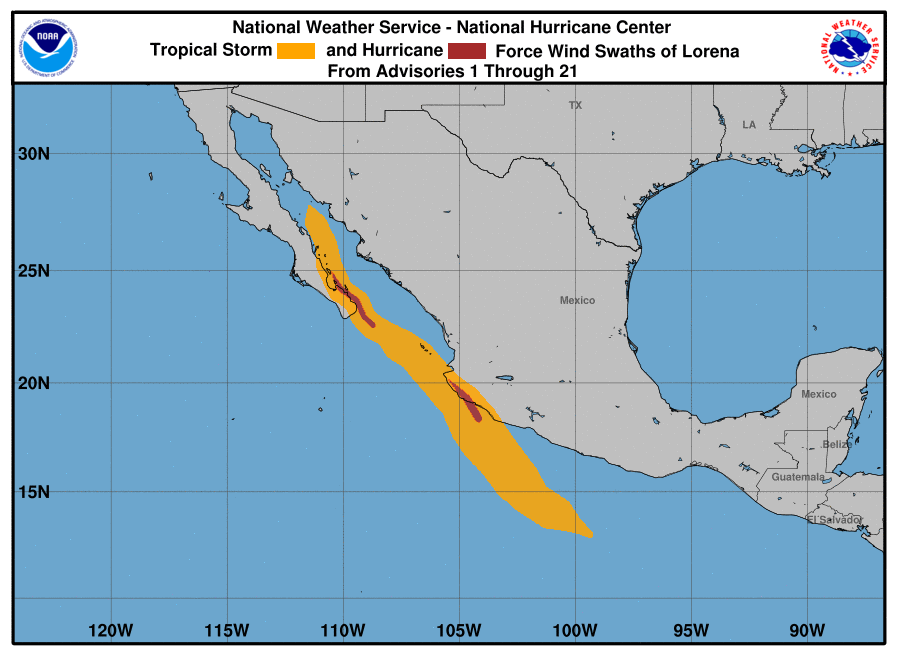
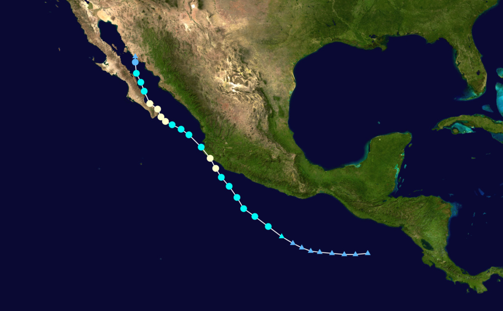
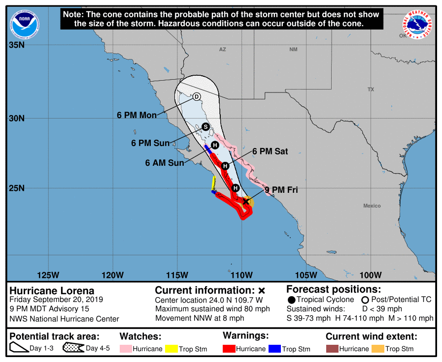
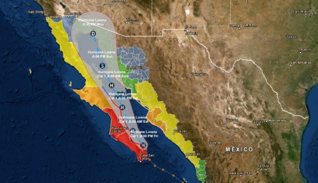
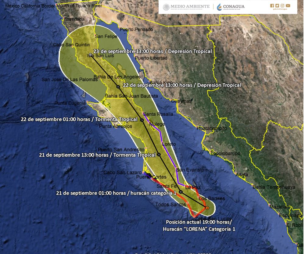
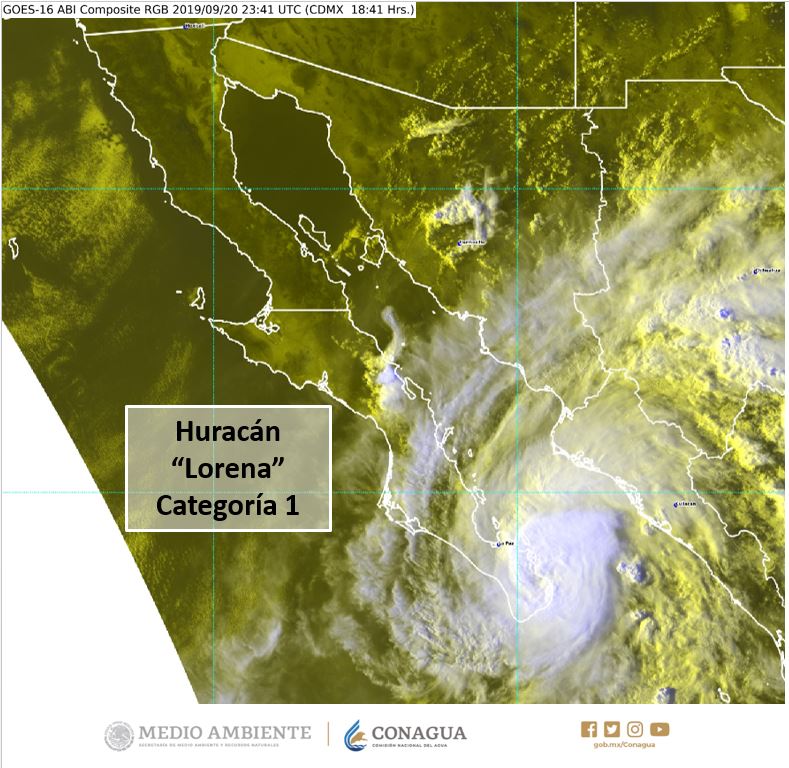
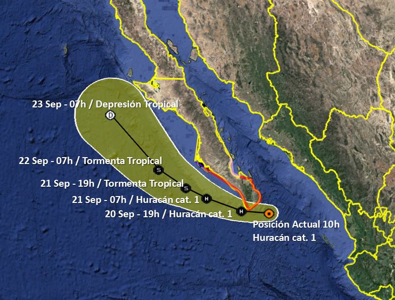
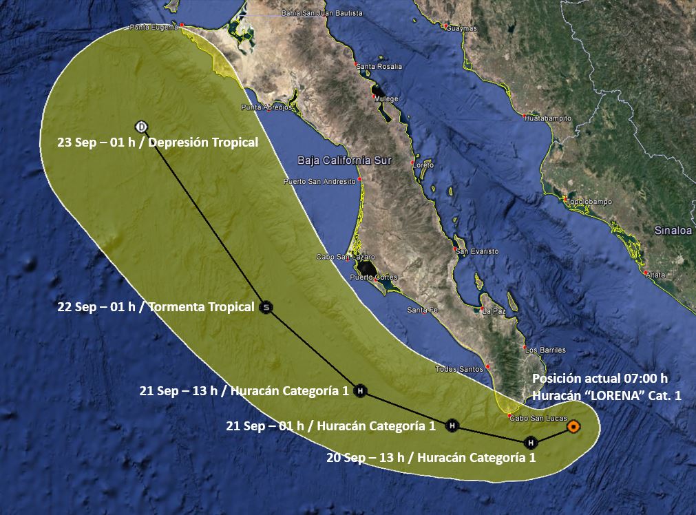
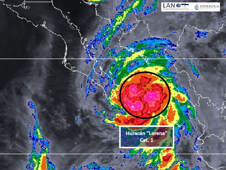
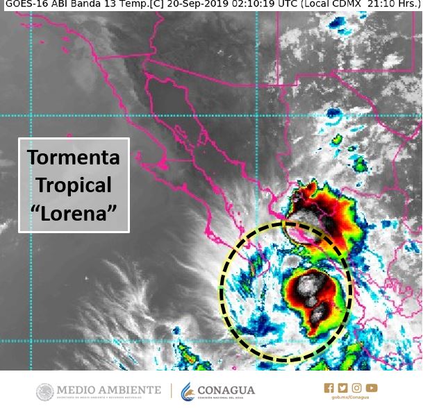
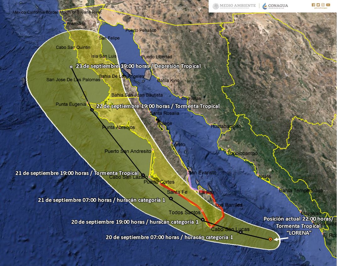
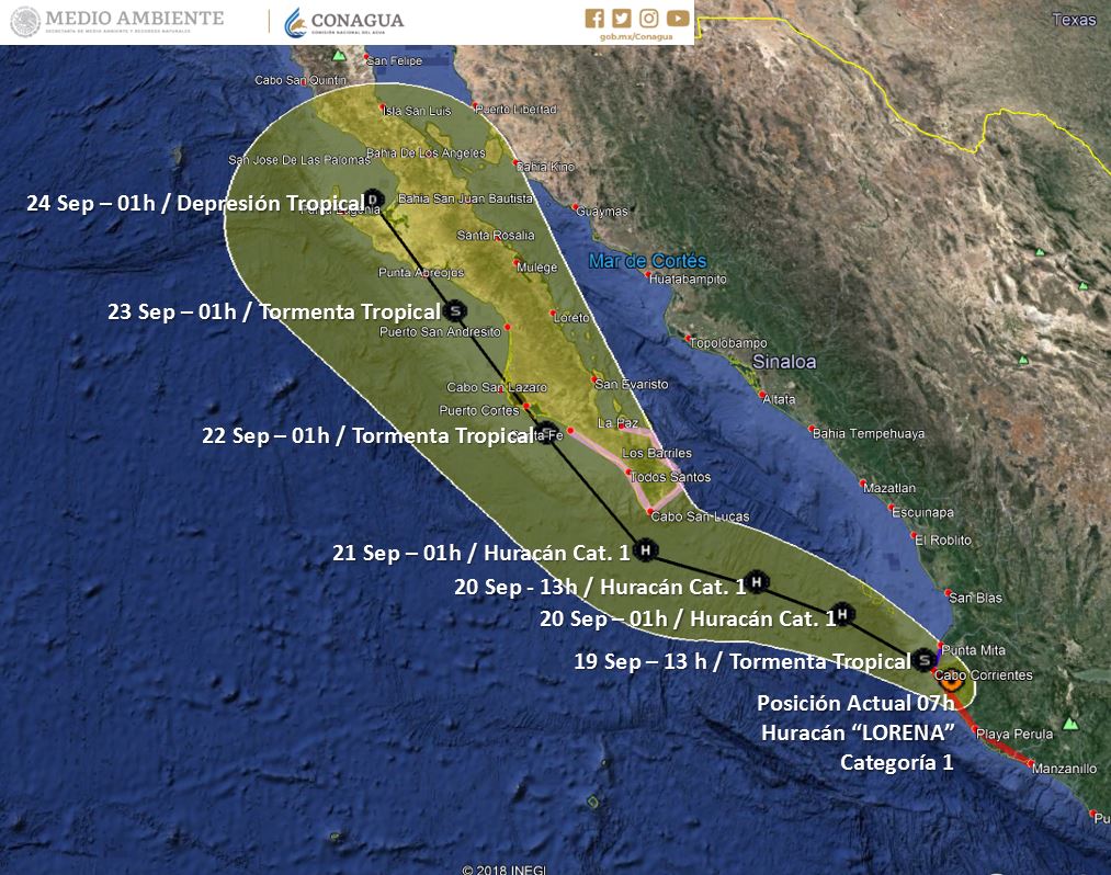
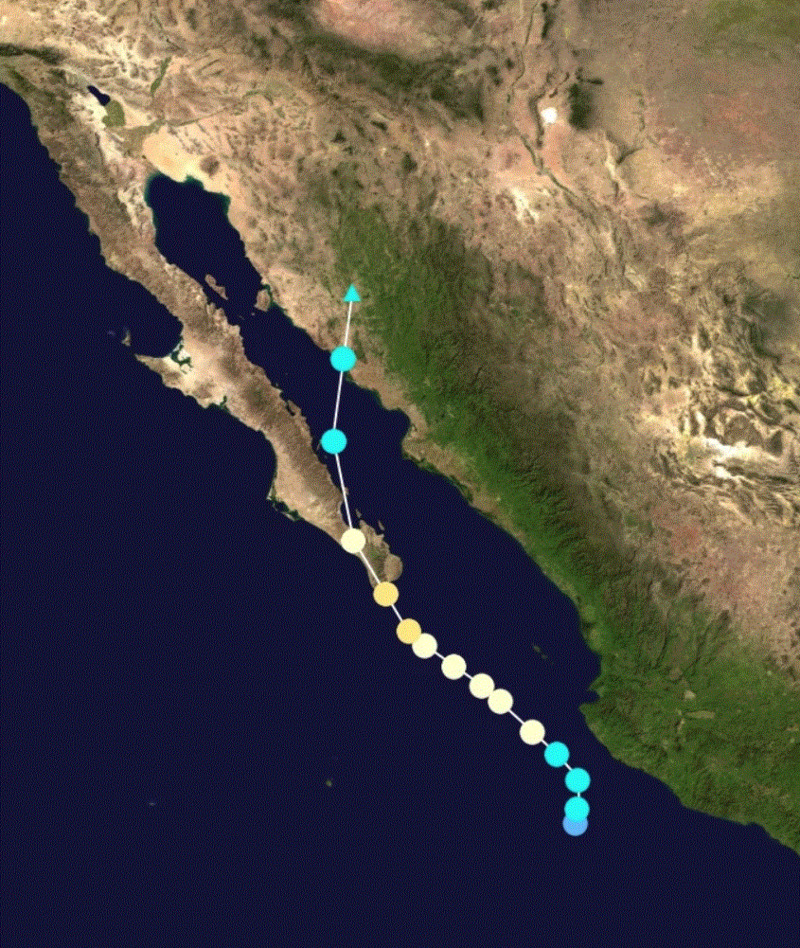
Hurricane Lorena...September 20, 2019. Lorena struck our area after suddenly changing course during the afternoon of September 20. Below are 2 images showing the NHC forecasts from noon, and from 9 pm.
This is a good example of why it is so important to hope for the best, but prepare for the worst. Although we were under a hurricane warning, the noon advisory showed the storm would likely pass just south of Cabo. The white area...known as the cone of uncertainty, is an indication of the track forecast errors over recent years. It is extremely important to remember that the cone only represents about 2/3 of all track errors, in other words, there is about a 30 percent chance the storm will move outside of the cone. Lorena was an extreme example of that!
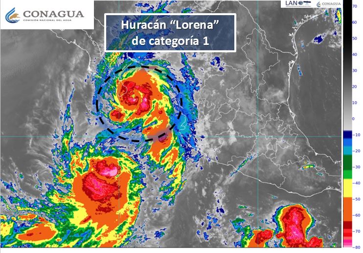
Below is a satellite image around the time of landfall near the lighthouse. The eye is clearly defined in yellow, and eyewitnesses just north of Bahia de los Suenos described a calm lasting about 20 minutes. I would estimate winds gusted to at least 100 mph at my home in El Sargento, and the calm here lasted about 10 minutes. There were several swaths of concentrated damage, particularly in El Sargento, which may have been the result of what has been documented in other hurricanes (Iniki and Andrew) as mini-swirls. They are just shallow spin-ups (not tornadoes), similar to a dust devil, that can easily add another 40 or 50 mph onto an already extreme background flow. I believe I experienced that, as at one point I heard a low-frequency roar approaching from the distance, the house shook, my ears popped, and the inside of my house filled with a light fog, probably due to a sudden drop in pressure. Crazy!! There were no indications of rotation in the damage, so it's unlikely that it was an embedded tornado. At least 8 steel-reinforced concrete power poles along the main road near me snapped off at ground level, and several homes near me had windows and sliding glass doors blown out.
We were fortunate there were no serious injuries or deaths. A big shout out to CFE who rebuilt the power grid near me in 4 days. Let's hope we don't see anything like that for a while!

dean- Posts : 5539
Join date : 2008-01-01
Re: hurricanes 2019
![]() by dean Mon Oct 14, 2019 7:12 am
by dean Mon Oct 14, 2019 7:12 am
well two day total I un-scientifically estimate by my buckers 4-6 inches of rain.
dean- Posts : 5539
Join date : 2008-01-01
Re: hurricanes 2019
![]() by dean Sat Sep 28, 2019 1:30 pm
by dean Sat Sep 28, 2019 1:30 pm
before we can blink and clean up here comes a storm to wash out what we just filed in.


dean- Posts : 5539
Join date : 2008-01-01
Re: hurricanes 2019
![]() by dean Fri Sep 27, 2019 8:44 pm
by dean Fri Sep 27, 2019 8:44 pm
this one gave more wind to our north side of town and the winds that were damaging stronger were from the north and same with water, here in LV about 2-4 inches of rain is my estimate. up north double that.
https://www.nhc.noaa.gov/archive/2019/LORENA_graphics.php?product=wind_probs_64_F120
https://www.gdacs.org/Cyclones/report.aspx?eventid=1000603&episodeid=11&eventtype=TC
https://www.apnews.com/4964277d65fd45bfabd4bb34d366b7ff
Hurricane Lorena skirts east coast of Mexico’s Baja
By IGNACIO MARTÍNEZ DE JESÚS
September 20, 2019
1 of 6
A tourist walks on the beach before the expected arrival of Hurricane Lorena, in Los Cabos, Mexico, Friday, Sept. 20, 2019. Hurricane Lorena neared Mexico's resort-studded Los Cabos area Friday as owners pulled their boats from the water, tourists hunkered down in hotels, and police and soldiers went through low-lying, low-income neighborhoods urging people to evacuate. (AP Photo/Fernando Castillo)
CABO SAN LUCAS, Mexico (AP) — Hurricane Lorena skirted along the east coast of Mexico’s Baja California Peninsula late Friday, prompting new warnings and watches for coastal areas but apparently sparing a direct hit on the resort-studded twin cities of Los Cabos.
The U.S. National Hurricane Center said Lorena was a Category 1 storm with maximum sustained winds of 80 mph (130 kph), and its center was about 40 miles (65 kilometers) east-southeast of the Baja California Sur state capital, La Paz. It was heading to the north-northwest at 8 mph (13kph) on a forecast track parallel to the coast through the Sea of Cortez.
https://www.usatoday.com/story/news/nation/2019/09/20/hurricane-lorena-path-los-cabos-flights-canceled-friday/2387842001/
Hurricane Lorena is headed toward the popular Mexican tourist destination of Los Cabos and could bring heavy winds and flash flooding Friday afternoon to the resort area.
The U.S. National Hurricane Center in Miami upgraded Lorena to a Category 1 hurricane Friday morning. Reports from the afternoon indicated that the storm had maximum sustained winds of 75 miles per hour.
https://en.wikipedia.org/wiki/Hurricane_Lorena_(2019)
Here were the claimed windspeeds
https://www.wunderground.com/hurricane/eastern-pacific/2019/post-tropical-cyclone-lorena?map=climo
https://mexiconewsdaily.com/news/erratic-hurricane-lorena-brings-heavy-rain-to-baja/
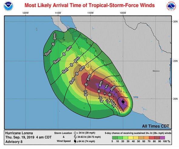
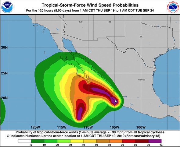
https://www.nhc.noaa.gov/archive/2019/LORENA_graphics.php?product=wind_probs_64_F120
https://www.gdacs.org/Cyclones/report.aspx?eventid=1000603&episodeid=11&eventtype=TC
https://www.apnews.com/4964277d65fd45bfabd4bb34d366b7ff
Hurricane Lorena skirts east coast of Mexico’s Baja
By IGNACIO MARTÍNEZ DE JESÚS
September 20, 2019
1 of 6
A tourist walks on the beach before the expected arrival of Hurricane Lorena, in Los Cabos, Mexico, Friday, Sept. 20, 2019. Hurricane Lorena neared Mexico's resort-studded Los Cabos area Friday as owners pulled their boats from the water, tourists hunkered down in hotels, and police and soldiers went through low-lying, low-income neighborhoods urging people to evacuate. (AP Photo/Fernando Castillo)
CABO SAN LUCAS, Mexico (AP) — Hurricane Lorena skirted along the east coast of Mexico’s Baja California Peninsula late Friday, prompting new warnings and watches for coastal areas but apparently sparing a direct hit on the resort-studded twin cities of Los Cabos.
The U.S. National Hurricane Center said Lorena was a Category 1 storm with maximum sustained winds of 80 mph (130 kph), and its center was about 40 miles (65 kilometers) east-southeast of the Baja California Sur state capital, La Paz. It was heading to the north-northwest at 8 mph (13kph) on a forecast track parallel to the coast through the Sea of Cortez.
https://www.usatoday.com/story/news/nation/2019/09/20/hurricane-lorena-path-los-cabos-flights-canceled-friday/2387842001/
Hurricane Lorena is headed toward the popular Mexican tourist destination of Los Cabos and could bring heavy winds and flash flooding Friday afternoon to the resort area.
The U.S. National Hurricane Center in Miami upgraded Lorena to a Category 1 hurricane Friday morning. Reports from the afternoon indicated that the storm had maximum sustained winds of 75 miles per hour.


https://en.wikipedia.org/wiki/Hurricane_Lorena_(2019)


Here were the claimed windspeeds
https://www.wunderground.com/hurricane/eastern-pacific/2019/post-tropical-cyclone-lorena?map=climo
https://mexiconewsdaily.com/news/erratic-hurricane-lorena-brings-heavy-rain-to-baja/
National Meteorological Service (SMN) chief Jorge Zavala said that Lorena’s “path has been extremely erratic and uncertain,” explaining that its trajectory changed from that which was forecast.
For days, forecasters had predicted that Lorena would make landfall in or very close to Los Cabos but the storm took a last-minute turn towards the east of the resort area.
More than 1,000 people took refuge in shelters in Los Cabos yesterday, while two shelters were opened in Loreto on Saturday, Baja California Sur Governor Carlos Mendoza Davis said. Authorities said that just under 200 people sought refuge in shelters in the state capital, La Paz.
Mendoza Davis said on Twitter on Saturday morning that no serious hurricane damage had been reported in either Los Cabos or La Paz and operations at airports in both locations had returned to normal.
The governor said that electricity will be restored to the communities of Los Planes and La Ribera later on Saturday and warned motorists to take care on the Los Planes highway as heavy rain caused a section of the road to collapse.
In Sonora, Civil Protection authorities have activated an orange alert


Last edited by dean on Wed Oct 16, 2019 6:42 am; edited 2 times in total
dean- Posts : 5539
Join date : 2008-01-01
Re: hurricanes 2019
![]() by dean Fri Sep 27, 2019 8:24 pm
by dean Fri Sep 27, 2019 8:24 pm
notes,
because LV area was the only area severly hit, we had some CFE crews replacing poles in one day. Telmex was out her the next day with a generator so those whos lines were not down had phone internet that evening.
CFE had power on for some people within the evening of the day after. And I had city water well I only checked the second day and it was on. I took a walk the next day and noticed one house had power and lines were down and hot to their neighbors which they had not done it this way before.
I put up a sign for CFE at my property because the neutral wire is broken, and they stopped and fixed my neighbors thinking that was the only one broken, so here I am a week later and still no repair. The good news for me is i did have 220 VAC so I could run my AC with that no problem. But I can not run my washing machine , laser printer, or microwave ovens as they are power-hungry at 110VAC. When I tried the laser printer my voltage dropped to 80VAC which if it was a motor like a washing machine can burn it out.
I am too busy getting ready for the next potential storm to go to LaPaz to do a formal report with photos. I did tie a path line that could allow me to run the washing machine.
So a recap on this storm it broke many concrete poles to the north past town. It was rated a cat 1 storm, but I believe there was a micro gust that exceeded 200mph north of town to break a concrete pole at its base. it should have knocked it over but it broke the base at about 2-3 feet from its base. I saw a truck from cfe leaving town with about 3-5 concrete poles where the tops were bent.
From my damage it was not close to wind speeds of ODile, Odile removed every single leaf from the plants. I have plenty of leaves left. Not nearly the water either. The stronger winds came from the north. My window that was not with a storm window to the north leaked into my room about half a gallon of water. I had a mop and bucket in the room.
This one did not give us much warning, it was projected to go west of the baja even when it became a something. I called a friend i believe it was 2 could have been 3 days before it and asked if they knew and they did not know. We were just barely in the projected/potential path. But it really shisted a bit the night before at about 3am a bit that concerned me. But they still had it going west of baja. But as it got close to san jose it did the change of direction just several hours before hitting us. It stalled on us dor over 2 hours. maybe 3.
dean- Posts : 5539
Join date : 2008-01-01

dean- Posts : 5539
Join date : 2008-01-01
Re: hurricanes 2019
![]() by dean Fri Sep 20, 2019 11:40 pm
by dean Fri Sep 20, 2019 11:40 pm
https://www.cyclocane.com/lorena-storm-tracker/
DISCUSSION AND OUTLOOK
----------------------
At 1200 AM MDT (0600 UTC), the eye of Hurricane Lorena was located
over land near latitude 24.0 North, longitude 110.1 West. Lorena is
moving toward the north-northwest near 8 mph (13 km/h). A general
motion toward the north-northwest or northwest is expected during
the next couple of days. On the forecast track, the center of
Lorena is expected to move along the east coast of Baja California
Sur or over the Gulf of California today, then approach the
northwestern coast of mainland Mexico tonight and Sunday.
Maximum sustained winds are near 80 mph (130 km/h) with higher
gusts. Little change in strength is expected through tonight.
After that time, Lorena is forecast to weaken.
Hurricane-force winds extend outward up to 10 miles (20 km) from
the center and tropical-storm-force winds extend outward up to 45
miles (75 km). An automated station in La Ventana, Mexico, recently
reported sustained winds of 69 mph (111 km/h) and a wind gust of 86
mph (139 km/h).
The estimated minimum central pressure is 986 mb (29.12 inches).
The same automated station in La Ventana reported a minimum pressure
of 991 mb (29.96 in).
dean- Posts : 5539
Join date : 2008-01-01
Re: hurricanes 2019
![]() by dean Fri Sep 20, 2019 9:49 pm
by dean Fri Sep 20, 2019 9:49 pm
it was way stronger, are we in the eye right now, can anyone tell me.
Hurricane john did not knock over my outdoor fridge or my 200 lb filing cabinet. The bad winds came from the north
my guess is gusts 90-110mph stopped 20 minutes ago so wondering if we are in the eye. and have another 2 hours of pounding coming, my gess is no because the strong winds were from the north.

dean- Posts : 5539
Join date : 2008-01-01

dean- Posts : 5539
Join date : 2008-01-01


dean- Posts : 5539
Join date : 2008-01-01
dean- Posts : 5539
Join date : 2008-01-01
Re: hurricanes 2019
![]() by dean Fri Sep 20, 2019 3:03 pm
by dean Fri Sep 20, 2019 3:03 pm
it appears it now a tropical storm and not vering to the west. Mexico removed it from being a hurricane. so peak rain later, we still have tropical force winds.

dean- Posts : 5539
Join date : 2008-01-01
Re: hurricanes 2019
![]() by dean Fri Sep 20, 2019 1:19 pm
by dean Fri Sep 20, 2019 1:19 pm
from what I see on the live satellite maps the water intensity has dropped. Right now we are just getting tropical force winds with very little rain. No serious rain since early this morning.winds about 20 with guest maybe 25mph.
dean- Posts : 5539
Join date : 2008-01-01
Re: hurricanes 2019
![]() by dean Fri Sep 20, 2019 11:30 am
by dean Fri Sep 20, 2019 11:30 am
strange at 3am it changed from the models, this concerns me... and the WU model below shows it backing up, so models may not be good.


dean- Posts : 5539
Join date : 2008-01-01
Re: hurricanes 2019
![]() by dean Fri Sep 20, 2019 10:02 am
by dean Fri Sep 20, 2019 10:02 am
this map still says it is to change direction and go west, pretty please....
still off and on rain and nothing major with off and on low 10-20 mph gusts. maybe 1/2 inch so far.

still off and on rain and nothing major with off and on low 10-20 mph gusts. maybe 1/2 inch so far.

dean- Posts : 5539
Join date : 2008-01-01
Re: hurricanes 2019
![]() by dean Fri Sep 20, 2019 7:33 am
by dean Fri Sep 20, 2019 7:33 am
stopped raining till now, gentle rain with blustery winds. rain amount maybe 1/8 inch so far. I will post pictures.


dean- Posts : 5539
Join date : 2008-01-01
Re: hurricanes 2019
![]() by dean Fri Sep 20, 2019 5:46 am
by dean Fri Sep 20, 2019 5:46 am
it is raining but dark so I do not know how much. we still have power. 7am
e

e

dean- Posts : 5539
Join date : 2008-01-01
Re: hurricanes 2019
![]() by dean Thu Sep 19, 2019 6:53 am
by dean Thu Sep 19, 2019 6:53 am
https://smn.conagua.gob.mx/es/pronosticos/avisos/aviso-de-ciclon-tropical-en-el-oceano-pacifico
e
e
dean- Posts : 5539
Join date : 2008-01-01
Re: hurricanes 2019
![]() by dean Fri Aug 23, 2019 10:02 am
by dean Fri Aug 23, 2019 10:02 am
well we got a little rain from Ivo today, not directly from Ivo but peripheral, maybe 1/8 to 1/4 in some places. the mountains probably much more. stopped about 30 minutes ago and it is 11am. still threatening looking as i can not see the island or the mountains due to cloud cover/fog. this rain came from the south with light wind.
yesterday the mountains to the west had a thick patch of dark clouds covering the top, so probably a gentle rain for many hours.
yesterday the mountains to the west had a thick patch of dark clouds covering the top, so probably a gentle rain for many hours.
dean- Posts : 5539
Join date : 2008-01-01
Re: hurricanes 2019
![]() by dean Thu Aug 08, 2019 12:04 pm
by dean Thu Aug 08, 2019 12:04 pm
rain today gentle started about noonish this morning was not humid at all.
the sea of Cortez seems cold to me about 80-82 for this time of the year so could get lucky and no hurricanes come directly at us if they start up.
the sea of Cortez seems cold to me about 80-82 for this time of the year so could get lucky and no hurricanes come directly at us if they start up.
dean- Posts : 5539
Join date : 2008-01-01
Re: hurricanes 2019
![]() by dean Sat Jul 20, 2019 10:02 am
by dean Sat Jul 20, 2019 10:02 am
we just received a 1/2 hour of light rain. awesome.... maybe up to 1/8th of an inch of rain, i will check my buckets later. The rain is not hurricane-related, airflow from the mainland sent this our way.
dean- Posts : 5539
Join date : 2008-01-01
Re: hurricanes 2019
![]() by dean Fri Jun 28, 2019 6:49 am
by dean Fri Jun 28, 2019 6:49 am
alvin which is far away is giving us a few clouds and a beautiful sunrise this morning. No rain in the mountains is the disappointment.
dean- Posts : 5539
Join date : 2008-01-01
hurricanes 2019
![]() by dean Mon May 27, 2019 11:37 am
by dean Mon May 27, 2019 11:37 am
https://hypotheticalhurricanes.fandom.com/wiki/2019_Pacific_hurricane_season_(Olo72)
2019 Pacific hurricane season
2019 Pacific hurricane season
The 2019 Pacific hurricane season was a very active Pacific hurricane season, featuring twentyone named storms, 14 hurricanes, and 8 major hurricanes, though .The season officially started on May 15 in the eastern Pacific, and on June 1 in the central Pacific; they both ended on November 30. These dates conventionally delimit the period of each year when most tropical cyclones form in the basin. However, the formation of tropical cyclones is possible at any time of the year.The season saw above-average activity in terms of ACE.


dean- Posts : 5539
Join date : 2008-01-01
Page 1 of 1
Permissions in this forum:
You cannot reply to topics in this forum